PAS 128 GPR Utility Mapping Surveys
TECHNICAL OVERVIEW
British Standards Institution PAS 128, Specification for underground utility detection, verification and location is the publicly available specification document which allows the utility survey industry to deliver its services to a recognised level of accuracy. Although it is aimed at the survey practitioner, we understand that our clients need a know how to specify a PAS 128 survey.
Our Process
We will receive an initial enquiry about a project.
Survey boundaries are discussed and defined. Along with site address, contacts and access arrangements/constraints.
Prior to our site visits we request for the Topographical base plan to be provided to us along with any Utility Record Drawings that may be available, if there are none available we offer to do a Desktop Utility Record Search pack.
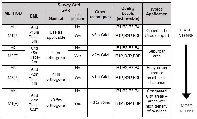
The Spec is discussed and agreed, ranging from M1 (least intense) to M4 (most intense)
Once this has all been arranged and is in place we go to site to conduct our on site PAS 128 Type B Survey
We recommend that the survey area is cleared ahead of, and for the duration of the survey, as vehicles, construction materials, temporary fencing or other obstructions may limit the effectiveness of our investigation.
If practicable, areas of vegetation should be cleared ahead of our arrival.
If practicable, areas of grass should be topped/mown as short as possible ahead of our arrival. Instruction should be given to estate management or grass mowing teams not to operate whilst surveying is underway, unless agreed with the survey team, as survey ground markings may be lost; necessitating works to be re-done.
If possible, site occupiers should be made aware of our survey and requirements ahead of our arrival.
The client should make us aware of any known unusual or site specific hazards as soon as is reasonably practicable, and ahead of our arrival on site.
See an example of our Method statement.
Once all survey data has been collected on site, the results are taken back into the office where the data can be processed and the CAD drawings produced, after vigorous checks these drawings are then issued to the client.
DRAWINGS PROVIDED
We issue both PDF and latest AutoCAD drawings of our survey results.
All of our drawings would be issued onto the Topographical base plan provided to us in AutoCAD format, each colour coded line is individually layered with clear depths and notes referencing to the line, which can be found in the drawing legend.
PAS 128 Quality levels are also indicated on the drawings.
EQUIPMENT USED
Latest Radiodetection RD8100 precision locators.
Radiodetection, GSSI & Cobra Multifrequency Ground Penetrating Radar Systems.
Radiodetection Flexitrace
Radiodetection Sewer Sondes on Flexrods
Specialist Manhole lifting equipment
GNNS GPS Surveying Equipment